It’s a well-known fact that archaeologists love to get their hands dirty – eternally, meticulously digging in the earth for ancient artifacts. But on this sunny day late last summer, Quentin Mackie is not on land, but aboard a Parks Canada ship on loan to the researchers. He is looking for a lost civilization under the water.
As the boat bobs gently, I take in the view – 360 degrees of stunning, green mountains rising from the sea – part of Gwaii Haanas National Park Reserve and Haida Heritage Site, a place of almost mystical beauty off the west coast of mainland British Columbia. Dr. Mackie, an associate professor of anthropology at the University of Victoria, points to the dark, inscrutable expanse of Juan Perez Sound that surrounds us. “We’ve got the AUV out there, and we’re looking for fish weirs,” he says.
The AUV, or autonomous underwater vehicle, is a remote-controlled submersible vessel that bristles with sensors. A few minutes later, slowly but surely, a yellow torpedo-like watercraft emerges from the depths like a small submarine, with the University of Victoria’s crest emblazoned on the side. “If we find what we’re looking for,” says Dr. Mackie, momentously, “it could be one of the oldest archaeological sites ever discovered in the Americas.”
While people often speak of Canada as a young nation, that’s far from the truth. Just off our vast coastline, the longest of any country on earth, researchers in various related fields are uncovering a whole new world, a sort of northern Atlantis that hosted indigenous peoples for thousands of years on land that is now completely submerged. It’s challenging work but experts note that, with recent improvements in technology, there is the potential for many great discoveries.
A few weeks later, I meet Dr. Mackie in his snug office at the university and ask him what they’ve found. While warning that reading such results can be a bit of a “black art,” he shows me two images: one, with splashes of red, green and blue, looks a bit like a weather map forecasting a big, incoming storm; the other appears to be the surface of the moon. Pointing to the second, Dr. Mackie explains that fish weirs were small, stone walls that ancient peoples built across streams in order to corral salmon for food. Accordingly, he and his team were looking for anything that appeared to be man-made and out of place, especially straight lines, right angles or other formations unlikely to have been formed by nature.
He points to a string of little black marks on the computer screen, which he explains are basketball-sized rocks that run across an old river channel. Dr. Mackie notes a number of items that brought this site to their attention: the straight-line structure, the fact that the rocks are a size that could be easily moved by men and that they appear to have been added to the location, the wall’s knee-high size, and the way the lines are angled in a downstream direction. It’s too early to know for sure, but all of these things seem to suggest that this is indeed a very old fish weir. If confirmed, it would be the oldest sign of human habitation in Canada.
“It fits very well with our model, that it’s cultural and not natural,” he says. “And because this is at 122 metres below the surface, we know that the last time this was dry land, when people could’ve walked on that land and built that wall, was 13,700 years ago.”
And it isn’t just one weir. Dr. Mackie observes that the waters of Juan Perez Sound now cover what was probably once a robust society – one with strong connections to the present. “I believe, in the case of Haida Gwaii, people were roaming all over the now-drowned Hecate Strait,” he says. “And people might be surprised to know that there is every indication the stories these ancestral Haida told of their times of great transformation of the world are still told by Haida people to this very day.”
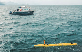
Juan Perez Sound. Photo courtesy of the University of Victoria.
Halfway across the country, Joe Boyce is searching for similar, ancient submerged landscapes. He’s also aided by cutting-edge technology, including the use of an AUV and side-scan sonar imaging. Dr. Boyce, an associate professor in the school of geography and earth sciences at McMaster University, notes that this technology can survey thousands of square kilometres in a relatively short amount of time, returning information on underwater environments that would have taken divers literally decades to map.
A geophysicist by training who works as a geo-archaeologist (he applies earth sciences toward the understanding of archaeological environments), Dr. Boyce has seen the potential of these devices in his work mapping early Bronze Age sites in Greece and Turkey, one of his two major areas of research. The other is his search for paleo-Indian sites long hidden underwater in the Great Lakes region, particularly in Rice Lake near Peterborough, Ontario. There, he has discovered submerged sites unseen for as many as 12,000 years after water levels rose rapidly.
“The ice sheet was just pulling back. It was an arctic, tundra landscape, very barren. It would’ve been a radically different landscape than what we see today,” he observes.
In his mapping of prehistoric shorelines, Dr. Boyce has found, among other things, a place where tools for hunting were made and sharpened more than 9,000 years ago. “With the advent of AUVs, we can now launch squads of these robots, working in tandem, mapping the sea floor. It’s a revolution,” he says, adding, “The biggest area for archaeological potential is underwater, and the coastline of Canada has literally millions of square kilometres of continental shelf that were terrestrial environments for prehistoric peoples.”
But, while it can be rewarding, UVic’s Dr. Mackie notes that underwater archaeology is expensive. A single submersible like the one employed in Haida Gwaii costs around $1.5 million – funds that can be hard to justify for cash-strapped archaeology departments. “When you’re doing the underwater stuff, you’re into large-scale science budgets in a social science discipline. There’s a disconnect there, in terms of funding,” he says.
Trevor Bell has encountered similar challenges in his underwater archaeological work at Memorial University, but he says it’s all worth it. Like Dr. Mackie and his team, Dr. Bell, a professor of geography at Memorial, is interested in prehistoric coastal Canadian landscapes. Using high-tech acoustic-imaging equipment, as well as divers, Dr. Bell has mapped a portion of the coastline off Newfoundland and Labrador – and in the process changed the prehistoric record on how long people have lived in the area.
While experts previously thought that this part of Canada had been inhabited for only about 5,000 years (something supported by terrestrial archaeological research), his underwater findings show that, in fact, maritime archaic peoples have lived here almost twice that long. “We see a gap between 5,000 and 9,000 years ago. People were probably here for 4,000 years on that submerged coastline,” he says.
Dr. Bell agrees there are unique challenges to this work. He says that while many major terrestrial archaeological sites have been found by accident – when foundations are dug for buildings, for example – this never happens underwater. That means the search for evidence is always going to be more expensive and time-consuming, especially given Canada’s long coastline.
But the research has many implications beyond archeology. The data, he says, can be used by everyone from oil companies exploring for petroleum to technology outfits looking to lay underwater cable to cruise ships navigating in areas beyond the shipping lanes and therefore not particularly well mapped, especially in the Far North. Indigenous peoples, as well, are using these findings to map their ancestry and heritage.
Society at large can also make good use of the lessons learned under water in an age of global warming, says Dr. Bell. “With more research, we will be able to see how ancient peoples adjusted to and reacted to rapidly rising sea levels – to see, culturally, how they responded. Those facts are currently locked away in submerged landscapes.”
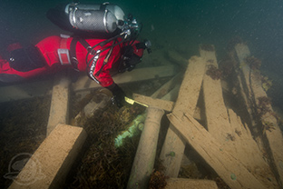
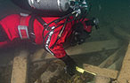
measures the diameter of a cannon found with the wreckage
of the HMS Erebus. Photo by Thierry Boyer, Parks Canada.
The technology used to uncover these ancient civilizations can, and has, also been used to find more recent underwater artifacts – most notably the HMS Erebus in present-day Nunavut. Famously discovered this past summer, the Erebus and its sister ship, HMS Terror, under the command of Captain Sir John Franklin, disappeared without a trace in the gunmetal gray waters of the Victoria Strait, in the Arctic Ocean, off the Nunavut mainland, in 1845. While the recent search efforts were led by a small group of Parks Canada staff, a number of academic researchers contributed to the mission, including Robert Park, an archaeologist at the University of Waterloo who, with his team, followed clues provided by the historical record and present-day Inuit populations.
Not so long ago, underwater archaeology was a much more labour-intensive endeavour, notes James Tuck, former chair of the archaeology unit and currently professor emeritus and Henrietta Harvey Professor of Archaeology at Memorial. He was part of a team that discovered the 16th-century Basque galleon San Juan (along with two other galleons and several smaller boats) off Red Bay, Labrador, in the late 1970s.
Back then, Dr. Tuck says, the hard work of searching was done by human divers, sometimes even laypeople who volunteered their time and skills under the direction of archaeologists. Dr. Tuck found a number of key pieces of evidence of Basque whaling activity on land that traced a path into the water and led to the discovery of the ships. He helped guide the divers to the discovery and remembers well the moment the ship’s presence on the sea floor was confirmed. “It’s always exciting to find something that nobody’s seen for 500 years,” says Dr. Tuck.
All of this – an emerging field of study aided by new technology – has some talking of a new age of exploration for this country. “People have been in the land mass now called Canada for close to a hundred times as long as there has been a political entity with that name,” says UVic’s Dr. Mackie. “During that time, countless other nations have risen and fallen here.”
Editor’s Note: In the original version of the article, we incorrectly stated that the location of the Victoria Strait was near Newfoundland. The correct location is now included: in the Arctic Ocean, off the Nunavut mainland.